
Enterprise Asset Management systems (or EAM) help organizations manage their physical assets throughout their lifecycle. ArcGIS Indoors enables those assets to be located, queried, tracked, and navigated to in a centralized map database. Integrating these two technologies provides a single pane of glass through which to visualize and manage an organization's building assets.
EAM systems support scheduled maintenance, work order management, asset inventories, performance monitoring, compliance and risk management, and cost control. Examples of EAM systems include IBM Maximo, Infor, SAP, Oracle, AssetWorks, and UpKeep. These EAM systems typically manage data in structured relational databases and include open Application Programming Interfaces (APIs) to provide other business systems with real-time access to asset data.
EAM’s are the authoritative source of record for asset information in most organizations, in the same way that Geographic Information Systems (GIS) databases are the authoritative source of spatial information. Integrating GIS data with EAM systems is critical to providing the geographic context for assets to support decision-making, plan maintenance, allocate resources, and reduce costs.
Integration between GIS data and other business systems to provide geographic context is nothing new. However, advancements in indoor mapping and the development of ArcGIS Indoors mean that an organization’s GIS can now serve as the single source of truth for spatial information down to the room level and below, in 2D and 3D space, while also taking into account floor-level information.
Advances in Indoor Positioning Systems (IPS) and the Internet of Things (IoT) mean that more and more smart devices report not only their status and sensor readings, but also their location. GIS platforms are uniquely positioned to integrate data from various business systems into a consolidated, centralized view connected by the common denominator - location.
GIS - The single source of truth for geospatial data, integrating real-time data from enterprise business systems via the common denominator: location.

For facility managers in charge of maintaining and managing building assets, GIS provides the following capabilities:
Map of asset locations: Provides a spatial overview, showing assets categorized by type, condition, age, status, service history, and other characteristics.
Geographic context: Data regarding assets, such as utility networks, natural features, transportation routes, and structural, topographic, and demographic features.
Proximity analysis: Data to help answer questions like - How far is the nearest fire extinguisher, AED unit, emergency exit, smoke alarm, or control panel, from a given location? How many assets are within a given radius of a position, or within a building or campus? Where is the nearest pump station or shutoff valve?
Maintenance Planning: Ability to prioritize maintenance based on areas with most needs, and optimize routes for maintenance crews.
Risk Management & Emergency Planning: Mapping of critical assets, and identifying areas at risk from natural disasters and other hazards.
Suitability Analysis: Review of asset locations for required space, and compliance with environmental and safety regulations
Public Engagement: Interactive maps for the public and other stakeholders showcasing asset allocation and distribution.
Facility managers looking to leverage the integration of GIS and Asset Management systems should consider the following key data management strategy recommendations:
Avoid Data Silos: Eliminate data redundancy, identify systems of record
Leverage of APIs: Allows real-time data integration
Automate Data Synchronization: Scripting and automated data workflows
Establish Common Data Standards: Universal Unique Asset IDs, domains, etc.
Quality Assurance and Quality Control (QAQC): Set and enforce data standards and validation rules
Data Governance: Establishment of roles and responsibilities
Change Management: Develop documentation and communication standards regarding data management strategy changes, provide training to the organization and new members
Data integration between EAM systems and GIS can be achieved in a number of ways, with the optimal solution depending upon the specific data types and business systems and practices already in place within an organization. Highly customized solutions are typically a requirement, so it’s important to make use of the widest range of tools available.
When dealing with spatial data in particular, Safe Software’s Feature Manipulation Engine (FME) software and the ArcGIS Data Interoperability extension, in conjunction with Python scripting, are extremely powerful for creating configurable and scheduled data Export, Transformation, and Load (ETL) tools to synchronize data from various sources.

Linking asset data to ArcGIS Indoors
A standardized, universal, unique identifier (UUID) is an essential component for integrating asset data with GIS. The asset ID should be unique not only within the EAM, but across all other business systems. The asset ID should be created when the asset is first defined, either at the design stage or during procurement, and stay assigned to the asset throughout its lifecycle. As assets change location or designation during their lifecycle, the unique IDs often do not contain any location information or descriptive classification, although this depends upon the organization's preferences. An example of a non-descriptive, non-spatial asset ID solution are hexadecimal UUIDs. These are made up of 32 digits and 4 hyphens, for example: 123e4567-e89b-12d3-a456-426655440000. These IDs are highly unique, with exceptionally small chances of duplication. See more on Global IDs/UUIDs here.
The asset ID is the key connecting thread of information linking the spatial data in GIS to the non-spatial data in EAM. Data should not be duplicated between systems where it can be avoided, however certain key data fields such as name, type, and description are often copied across for labeling and performance purposes during data synchronization.
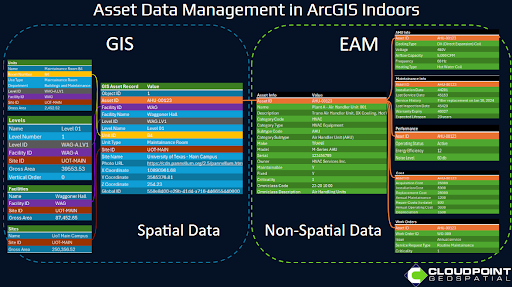
By connecting asset data to the ArcGIS Indoors Information Model (AIIM), indoor mapping datasets can be enhanced by making asset information “floor aware”. This is the concept of attributing each feature with a building level ID in order to filter by floor when visualizing and querying indoor mapping data.
The end result is a GIS database containing mapped building assets that can be filtered by floor, and connected to real-time asset information from the organization's EAM. This integration opens up asset data to be explored within GIS applications and dashboards, providing dynamic, interactive geospatial context for an organization's asset data.

Indoor Mapping Application showing building assets by category and floor level

Asset Inventory Dashboard built using ArcGIS Indoors

Asset Editing App built using ArcGIS Indoors

Asset Editing App built using ArcGIS Indoors
(Data from screenshots shown courtesy of the University of Texas at Austin)
For more information on how to enhance asset management for your facilities using ArcGIS Indoors contact Cloudpoint Geospatial’s professional services team.