
The ArcGIS Data Interoperability extension, available from Esri as an add-on for ArcGIS Pro, is a powerful tool for GIS professionals. It offers an impressive suite of features for data integration, transformation, and automation. Built on Safe Software’s Feature Manipulation (FME) technology (https://www.safe.com/) , this extension provides a Visual Development Environment (VDE) for designing custom Export, Transform, and Load (ETL) workflows.
FME has been continually developed since 1993, when it was first created to convert Canadian forestry data from CAD to GIS format. Since then, it has grown to include hundreds of data formats, database types, cloud platform integrations, and a large user community contributing custom data integration tools to the FME Hub.


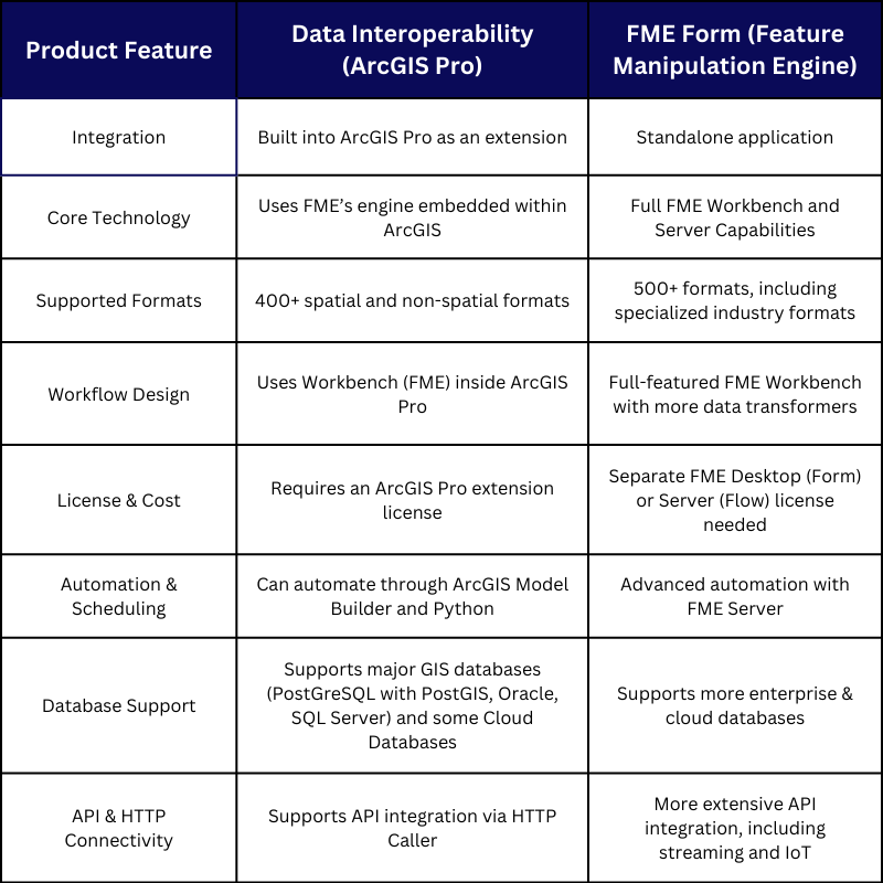
The ArcGIS Data Interoperability extension is essentially a version of FME licensed by Esri, integrated within the ArcGIS platform, and tailored for GIS users. It can be launched from within ArcGIS Pro, via the analysis toolbar, as a new Spatial ETL Tool, or opened as a standalone application.
The FLE Workbench application allows you to create custom Export, Transform, and Load (ETL) workflows and run them as geoprocessing tools within ArcGIS Pro. You can also share these tools with other ArcGIS Pro and FME users.
It allows for seamless data integration across multiple formats, enabling users to:
Read and write over 400 spatial and non-spatial data formats
Transform data by merging, filtering, reformatting, reprojecting, and converting
Automate ETL workflows using Python scripting
While the full FME software (FME Form) supports over 500 formats and offers additional advanced processing capabilities, the Data Interoperability extension includes the essential tools required for most GIS ETL processes.
ArcGIS Data Interoperability and FME Form: Key Differences
Key Features and Benefits
Easy-to-Use FME Workbench Application
If you’re familiar with Model Builder in ArcGIS, you’ll appreciate the drag-and-drop interface of the FME Workbench. It allows users to visually construct workflows by adding transformers that process data in sequence.
Data Transformation Capabilities
Beyond simple format conversions, the extension provides extensive data transformation tools, including:
Attribute manipulation: adding, renaming, grouping, and summarizing values
Spatial operations: converting geometry types, integrating data from multiple sources
Automation validation: checking for errors in geometry and attributes
Automation with Python
Python scripting enhances ETL automation capabilities, enabling:
Scheduled execution of FME workflows
Email notifications for completed tasks
Custom scripts embedded within ETL processes
Use Cases for GIS Professionals
The extension’s capabilities extend beyond simple data conversion. Here are some real-world applications:
Data Quality Control & Validation
Geometry and attribute validation, checking against rules and standards
Topology checks to ensure spatial integrity
CAD & BIM to GIS Conversion
Converting CAD and BIM layers to GIS objects
Validating polylines and snapping features
Schema Migration
Transforming and migrating between GIS data schemas
Mapping attributes to new field names
Data Enrichment
Merging multiple spatial and non-spatial sources
Spatial and joins for enriching datasets
Integration with Enterprise Systems
Live connections to databases like Oracle, SAP, and IBM among others
Real-time data updates into GIS
Data Cleanup & Reformatting
Removing duplicates, ensuring uniqueness, rounding, trimming, concatenating and extracting sub-strings
Filling in null values based on criteria
Overview of the FME Workbench Application Interface
The basic operation of the FME Workbench application is to add a data reader (or multiple readers) to the left side of the workbench, then add some transformers that interact with and transform the data, and finally add a data writer or multiple data writers to export the data to the format you require.
The Visual Preview panel and Graphics panel are essential for investigating the content of your data at every step of the process. A more detailed inspection can be made by opening the FME Data Inspector (a separate application also included with Data Interoperability) that provides a full-screen data review interface, including a map window.
Example Workbench converting Building footprints and Building Points from CSV and XML format to Geodatabase format, with attributes filtered, renamed, and created along the way.
Recommended Transformers for GIS Workflows
Here are some recommended FME Transformers that support typical GIS workflows:
Final Thoughts
The ArcGIS Data Interoperability extension is an invaluable tool for GIS professionals, streamlining data integration and transformation processes. Whether you’re cleaning up datasets, automating workflows, or integrating online or enterprise data, this extension provides a robust solution within the ArcGIS environment.
If you need assistance implementing this tool, feel free to reach out - Cloudpoint is here to help optimize your GIS workflows!