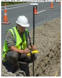
How do you find your underground utilities? Does your method of relocating them consist of your veteran public works director and the third-generation local excavator estimating them based upon a combined 70 years of memory? We find this all to common in today's communities where their baby-boom staff will soon retire and take with them an incredible amount of "tribal knowledge". Although they may have an incredible ability to tell where those 50 year old lines are at, someday these folks will not be available. That's why mapping these utilities with GPS equipment is so critical! Don't lose all of that valuable information, you just can't take that risk. It doesn't have to be expensive equipment that costs thousands of dollars. Even a simple $200 Garmin eTrex will get you headed in the right direction. Today's GPS equipment can provide accuracies that vary from five feet to five millimeters.In addition, if you are a local government agency that has a permitting process for underground utilities, why not start requiring the permittee to provide you as-builts with GPS coordinates. You can do this with a simple ordinance update and even specify the accuracy requirements, and they don't have to be overly tight. This is not an unreasonable request and will not place an "undue" hardship on them when the cost of GPS equipment is so insignificant these days. The point is once you have the data it can be used in so many different capacities. So why not set your agency on the right course today and make things better for the next generation!
Visit us at www.cloudpointgeo.com