

We are excited to share that Cloudpoint Geospatial has officially elevated our partnership with Esri from Silver to Gold status! This prestigious recognition places us among only 125 companies worldwide and highlights our ongoing commitment to delivering top-tier GIS solutions, driving innovation, and ensuring customer success.
Bigger Space, Bigger Dreams: Cloudpoint's New Office

We are excited to announce that Cloudpoint Geospatial has officially moved to a new office in Metamora, Illinois! After years of growth and success in our previous location in Roanoke, Illinois, this move marks a significant milestone for our team. Why did we move locations? The new office provides us with much more space and additional private offices, enabling us to continue expanding and meeting the needs of our growing team.
Taking it all in at the Esri User Conference

WASBO: Connecting with a Crucial Bunch

Not getting out lately??? Don't worry, we'll come to you!

Our team at Cloudpoint Geospatial has been busy planning a record year for our company in attending, exhibiting, lecturing at, and even hosting GIS events. “It’s expected to be a breakout year for us in multiple ways”, says company founder and CEO, Jonathan Hodel. “Our business development team has gone above and beyond with their strategic planning efforts this year, having over fifty…
Cloudpoint providing campus-wide ADA Compliance Survey

Cloudpoint celebrates 10 Years!

Congratulations to the entire Cloudpoint Geospatial team on celebrating their 10-year anniversary of providing professional GIS services. The company was originally incorporated on August 25, 2011 soon after founder Jonathan Hodel, entered the tech startup world when he built a website, sent out letters, and began evangelizing the power of GIS technology. Since then Cloudpoint has…
Best wishes Micah!
Cloudpoint earns Designation as Indoor Mapping Specialist

Becoming an Esri Business Partner was a key to fueling company growth and opening doors to new opportunities. “Our company’s partnership with Esri has boosted our name recognition and allowed for expertise to be noticed on a national verses regional scale.” says founder and CEO, Jonathan Hodel. Now this partnership blossoms once again as Cloudpoint announces they have received their ArcGIS Indoors specialty designation. This process involves completing an application to Esri and then demonstrating the company’s capabilities for indoor mapping by providing real-world examples of implementing this robust solution. This is the fourth Esri ArcGIS specialty designation that the company has received adding to its current accolades which include Local Government, ArcGIS Online, and Release Readiness designations.
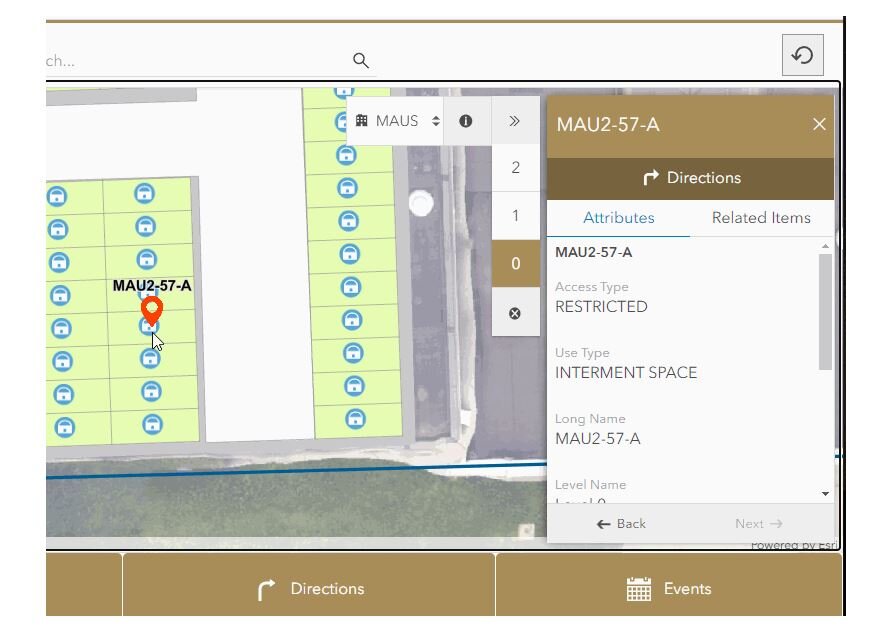
A sample snapshot of indoor mapping application ready to provide asset information or turn-by-turn walking directions. Easily select a building and floor level for easy navigation across a campus. You can image the power of this technology as we mitigate the return-to-work process following the COVID-19 pandemic. Things like space management, foot traffic patterns, route planning, and room cleaning updates can all be tracked via an active Indoor GIS system.
Implementing the ArcGIS Indoors solution across an organization, especially a campus-wide project, requires expertise in several areas of GIS including Enterprise GIS deployment, data conversion of CAD or BIM files, GNSS collection for control points, 3D laser scanning equipment, drone imagery, data curation in ArcGIS Pro, publishing web layers, and more. The Cloudpoint team has experience in bringing all of these capabilities together in a seamless fashion to create an immersive interactive campus experience for the end user.

The end results can be as simple as using Esri’s Indoors web application template along with their Indoors native mobile app, or expanded to include a robust customized GIS interface having the ability to integrate with monitoring sensors and real-time location system (RTLS). For many years, GIS has continued to transform the way people engage with locational data and indoor facility mapping will be the catalyst for engaging in more detail in the future.
For more information on how your organization can harness the power of GIS indoors, visit our Indoors page or contact our team of professionals at 877-377-8124.
Cloudpoint hosting free webinars with GIS training!
The Cloudpoint team is taking advantage of this time of remote connectivity to connect with you in a whole new way. Our professional GIS experts will be hosting a series of exciting GIS webinars to help users take advantage of the latest GIS resources. Although we can’t meet in person right now, here is a list of our upcoming virtual events that you won’t want to miss out on. Be sure to join our team for some high-impact learning opportunities to see how your organization can benefit from GIS!
How to Maintain Your Cemetery Records with GIS
Check out the recording HERE!
Overcoming your fear of ArcGIS Pro
Check out the recording HERE!
Upgrading Your Enterprise GIS: What It Means and How to Keep Up
Check out the recording HERE!
What Facility Managers Need to know about GIS
Check out the recording HERE!
Critical GIS Infrastructure Every Public Works Department Should Have
Check out the recording HERE!
How to Manage your Sign Inventory in the Cloud!
Check out the recording HERE!
Introduction to Parcel Fabric in ArcGIS Pro
Check out the recording HERE!