
Are you a GIS user that has transitioned from ArcMap to ArcGIS Pro? If so, Congratulations! If not, you might want to consider dipping your toes in the ArcGIS Pro waters (ArcMap is set to be retired by March 2026).
For the ArcGIS Pro users, or those thinking about making the move from ArcMap, you now have the capability to manage your land records data using the Parcel Fabric in ArcGIS Pro, with improved workflows and editing capabilities. Here are a few tidbits to know when “Going Pro” with the Parcel Fabric.
Configure Parcel Fabric
There are two options for setting up your Parcel Fabric in ArcGIS Pro with existing parcel data:

Upgrade an existing ArcMap Parcel Fabric

Migrate non-Parcel Fabric data to ArcGIS Pro
For the Upgrade option, The Upgrade ArcMap Parcel Fabric tool will do the trick. This tool takes the ArcMap parcels (parcel lines and parcel polygons) and transfers them to an ArcGIS Pro Parcel Fabric based on the type of parcel. Parcel type feature classes in the Pro fabric are generated from the value of the “Type” field in the ArcMap parcels. Other layers such as historic parcels, points/control points, and plans are also transferred (more on that later). One thing to remember when upgrading is to delete coincident duplicate lines that are generated in adjacent parcels of differing parcel types.
For the Migrate option, the process begins with creating a dataset (ParcelEditing, Land Records, etc.) in a project geodatabase, and then running the Create Parcel Fabric tool in ArcGIS Pro. Next, add your Parcel Types (tax parcels, PLSS sections, subdivisions, etc) via the Add Parcel Type tool. Additionally, you can then create any necessary subtypes, domains, and other attribute fields. To get your source parcel polygons into the Parcel Fabric, use the Append tool, then use the Create Parcel Records tool to transfer plans from the ArcMap fabric, and enable Parcel Topology.
***A third option for creating a Parcel Fabric is if you are starting from scratch and do not have parcel data, you can develop and build the parcels in ArcGIS Pro.
Changes
If you are familiar with the ArcMap Parcel Fabric, you may notice some differences in the ArcGIS Pro Parcel Fabric. Here are a few changes:
No joining or re-joining parcels. In ArcMap, new parcels need to be connected to the parcel fabric network. This is accomplished by creating join links between new and existing parcels using the Join and/or Rejoin commands. In ArcGIS Pro, these commands are unnecessary. Instead, use Editing tools (Align Features) in ArcGIS Pro to establish the connection.
Plans are now called Records. In ArcMap, recorded parcel information (plat of survey, deed, etc) is entered in the Plans related table in the Plan Directory of the Parcel Fabric. In ArcGIS Pro, plans are now called Records and are configured as a separate feature class in the Parcel Fabric.
Parcel Fabric schema. In ArcMap, the Parcel Fabric data model is setup so that features of the same data type reside in the same feature class; for example, the ParcelFabricParcels feature class contains tax parcels, lots, PLSS sections, subdivisions, etc. The features are displayed individually in the map based on definition queries of the parcel types. In ArcGIS Pro, the Parcel Fabric consists of individual feature classes for each parcel type. Also, as mentioned above, there is now a Records feature class-which was formerly a table in the ArcMap Parcel Fabric.
The Pro Experience
One adaptation ArcMap users need to make when transitioning to ArcGIS Pro is the Pro interface. It is a ribbon interface similar to Microsoft Office products, in which tabs are grouped by functionality (Insert, View, Edit, Share, etc.), and work is done within a Project.
As far as parcel editing goes, a major advantage is in ease of use of the ArcGIS Pro Editing tools.
Editing is automatically enabled so there is no extra step of starting an edit session.
The native editing tools within ArcGIS Pro are used to edit parcel data, while ArcMap had a separate toolbar specifically for Parcel Fabric.
Another option a Parcel Fabric Editor could take advantage of is multiple map views within an ArcGIS Pro project.
Common actions can be strung together as a task, and tasks can be converted to automated workflows.
When a Parcel Fabric is added to a map in ArcGIS Pro, a tool called a Heads-Up-Display is activated. The HUD is used for parcel record management; parcel polygons can be assigned to an active parcel record.
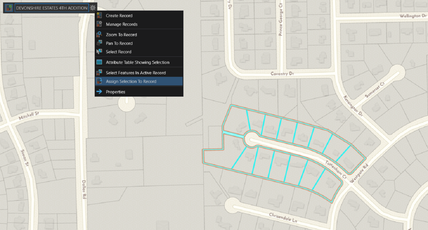
Assigning parcels to an active parcel record via the Head-Up-Display
If you are interested in learning more about the ArcGIS Pro Parcel Fabric, check out our webinar Introduction to ArcGIS Pro Parcel Fabric on Wednesday May 13 at 10am. We look forward to sharing this learning opportunity with you! You can also contact us at 877-377-8124, or via our Land Records page.