

A web map for viewing the city's current sidewalk inventory and conditions in real-time created using Web AppBuilder for ArcGIS.
1. Create a Web Map- Use your GIS to easily communicate pedestrian access routes (temporary & permanent) by displaying them on a web map and share with the public to communicate temporary road closures or construction activities to the traveling public. The routes can be added as a layer to the GIS and easily updated by office or field personnel to keep the public informed about designated routes or changes. ArcGIS Desktop can be used to digitize the routes and published via ArcGIS Server or ArcGIS Online. A user friendly interface can be created using Web AppBuilder for ArcGIS. Esri has a sidewalk feature class within the Local Government solutions that can be used as a layer in the GIS including domains for maintenance items and citizen complaints.
2. Rate your Sidewalks- Track your sidewalk conditions using ipads, smartphones, or laptops with field crews and your existing GIS software. The Village of Morton, IL is an example of an agency using their GIS for a sidewalk inventory and ratings system program. Ratings are conducted on sidewalk features such as cracking & spalling, slope, vertical displacement, and vegetation encroachment. These ratings are easily documented within the GIS by esri's Collector app along with user-friendly drop down menus that can make for efficient collection work.
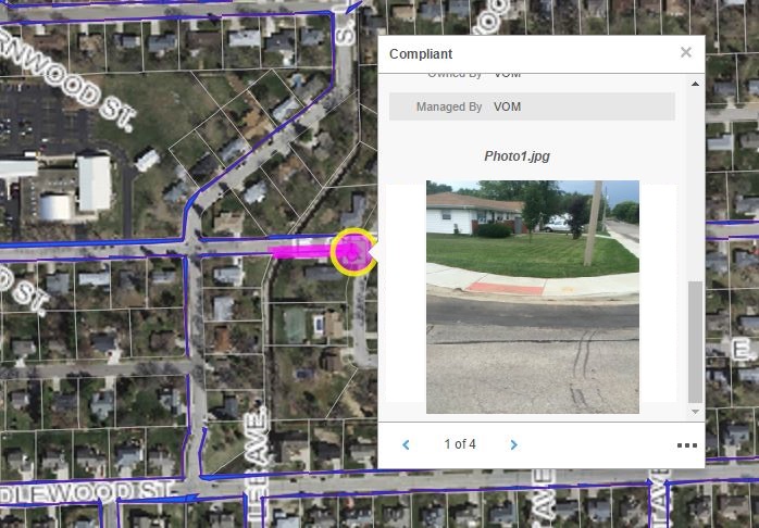
A photo of a curb ramp that was taken with an iPad using the Collector app is displayed here in the web application.
3. Inventory Ramps- Curb ramps are required to meet certain requirements for ADA compliance. Many agencies are still facing intersections with no ramp access to sidewalks and must document these as part of their upgrade plans. Questions and Answers About ADA/Section 504
4. Identify Trip Hazards- Trip hazards on pedestrian routes can be a major liability issue. Agencies must take careful notice to document these areas and create a plan of corrective action. Someone who is being diligent in documenting and inventorying these "problem" areas will most likely have a better defense in a court of law.

5. Locate Vegetation Overgrowth- Trees and brush can easily encroach onto sidewalks and walkways. If not maintained, they can become major hazards to pedestrians and need to be dealt with. Utilizing the GIS with applications like Esri Collector installed on ipads can be a great way to easily document these areas and integrate with field crews on work needing to be done.
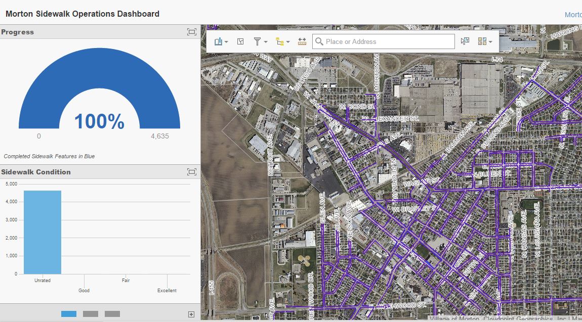
6. Create Dashboards- For managers and supervisors needing a real-time snapshot of their infrastructure conditions the Operations Dashboard for ArcGIS is an invaluable tool. Here they can easily see with the click of a button how many defects are currently present or the percentage of deficient sidewalks in the system. Because the dashboards are integrated with ArcGIS Online, the users are seeing the exact same data as field personnel and other users throughout the organization.
7. Public Transparency- These days the public expects total transparency from their local governments because this helps promote good stewardship. With today's GIS technology this has never been easier. Utilizing ArcGIS Online or ArcGIS server, these agencies can easily share this data across the platform and even make them publicly accessible. In many cases, publishing GIS data on infrastructure conditions can actually be a great tool to secure public support for additional funding or seeking grant money.
8. Public Input- Many people are utilitizing maps and apps these days to solicit crowd sourcing information. The GIS can be used in this case as a way for citizens to report problems with sidewalks. Citizens could use their mobile devices to log into the city's web application and report a complaint or hazard that exists on the pedestrian system.

9. Capital Improvement Planning- When planning construction projects and allocating maintenance dollars to improve sidewalk and pedestrian systems, government officials can be sure they are using a strategic approach that considers all aspects when they have accurate GIS data to make those decisions rather than a shot gun approach or "worst first" method in which local resources can sometimes be poorly utilized.
10. Pedestrian Navigation- We are all used to navigating the streets with GPS in our vehicles but what about navigating pedestrian routes. Take advantage of guiding people where they need to go on your pedestrian system using the GIS tools that are now available.